Exploring the Differences Between IP Geolocation and GPS-Based Location Services
Location-based information has become integral to numerous applications and services. Whether it's delivering targeted advertisements or enhancing security measures, understanding the location of users or devices is crucial. IP geolocation and GPS-based location services API are two widely used methods for determining location. In this blog post, we will explore the differences between these two approaches. Moreover, we will also delve into their unique characteristics and functionalities. We will also explore IPstack, a popular IP geolocation API.
IP geolocation is a technique that enables the identification of the geographical location associated with an IP address. On the other hand, GPS-based location services rely on satellite-based positioning systems to determine precise geographic coordinates. Understanding the distinctions between these two methods is essential for making informed decisions. Moreover, we will also learn and explore IPstack, a powerful location data or geolocation API. So, what are you waiting for? Let's continue reading the article till the end.

What Is IP Geolocation Service?
IP geolocation service is a method used to determine the geographical location associated with an IP (Internet Protocol) address. It allows businesses and developers to retrieve information about an IP address. IP geolocation involves mapping IP addresses to specific physical locations on the Earth's surface. This information can be invaluable for a wide range of applications across industries.
By leveraging IP geolocation data, businesses can tailor their services based on the location of their users or devices. They can provide localized content and target advertisements to specific regions. Moreover, they also prevent fraudulent activities and enhance security measures.
Developers can integrate IP geolocation services into their applications or websites using APIs. These APIs allow for easy retrieval of location-based information associated with IP addresses. One such example is IPstack.

IPstack
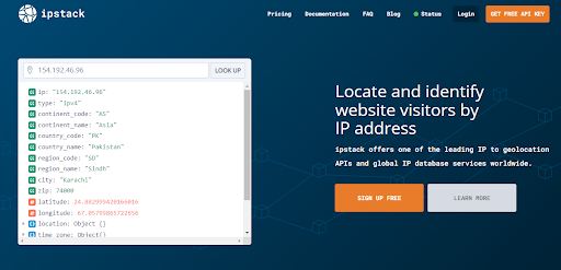
IPstack is an IP geolocation API service that provides developers with a reliable and accurate way to retrieve geolocation data for IP addresses. It offers information such as the country, region, city, latitude, longitude, time zone, and other relevant details associated with an IP address. IPstack gathers data from various sources, including regional internet registries, geolocation databases, and internet service providers, to provide accurate and up-to-date information. Let's check the features that Ipstack offers.
- Gain insights into your website visitors' locations and personalize user experiences based on their IP addresses.
- Access comprehensive IPv4 and IPv6 data. Furthermore, it covers 2 million unique locations in over 200,000 cities worldwide.
- Count on reliable and consistent data sourced from trusted partnerships with major ISPs.
- Receive dedicated technical support whenever you need assistance.
- Seamlessly scale your business with the IPstack API. It is designed for easy use and implementation in under 10 minutes, with guaranteed uptime.
- Benefit from a powerful and scalable infrastructure capable of handling requests ranging from 100 per month to a million per day.
- Utilize world-class documentation and a quick start guide to get up and running in minutes.
- Ensure the highest level of security with 256-bit SSL encryption (HTTPS) for all data sent to and processed by the IPstack API.
- Choose between JSON or XML format for result delivery based on your preference.
How Does IP Geolocation Work?
IP geolocation operates by associating IP addresses with their corresponding physical locations. This process involves different approaches, including database lookups or utilizing the Google Maps API. It helps to determine the geographic information linked to an IP address.
Here's a simplified explanation of how IP geolocation works:
- Every device connected to the internet is assigned a unique IP (Internet Protocol) address, which serves as its identifier.
- Geolocation service providers maintain databases that contain mappings between IP addresses and their corresponding geographic information, such as country, region, city, latitude, and longitude.
- Geolocation providers such as IPstack gather data from various sources, including internet service providers (ISPs), regional internet registries (RIRs), public databases, and proprietary data.
- The collected data is aggregated, cleaned, and organized to create comprehensive geolocation databases. This data is regularly updated to ensure accuracy.
- When a request is made to determine the location of an IP address, the geolocation service performs a lookup in its database.
- The geolocation service compares the requested IP address with the entries in its database and finds the closest match. It retrieves the associated geographic information linked to that IP address.
IP geolocation finds practical applications in several scenarios. Some examples are adapting websites to local languages and cultures, modifying prices according to specific locations, delivering personalized content, and enhancing security measures.
What GPS-Based Location Service?
A GPS-based location service is a method that utilizes the Global Positioning System (GPS) to determine the precise geographic coordinates of a device or user. GPS is a satellite-based navigation system consisting of a network of satellites orbiting the Earth. GPS receivers on devices can communicate with these satellites to calculate their exact location.
GPS-based location services rely on a device's ability to receive signals from multiple GPS satellites and use the information to triangulate its position. GPS receivers can calculate latitude, longitude, altitude, and sometimes speed and direction.
GPS-based location services are commonly used in navigation systems, mobile applications, fitness trackers, vehicle tracking systems, and other location-dependent applications. They provide highly accurate and real-time location information. Hence making them valuable for precise navigation, tracking, and mapping purposes.
It's important to note that GPS-based location services require a clear line of sight to GPS satellites. Moreover, their accuracy can be affected by environmental factors such as tall buildings, dense forests, or interference. In such cases, alternative methods like Wi-Fi-based or cellular network-based location services may be used as fallback options.

How Does GPS-based Location Service Work?
Here's a simplified explanation of how GPS-based location services work:
The GPS consists of a constellation of satellites orbiting the Earth. These satellites continuously transmit signals that contain timing and positioning information.
The device or receiver seeking its location must have a GPS receiver chip. This receiver is responsible for capturing signals from multiple GPS satellites.
The GPS receiver needs signals from at least four GPS satellites. Moreover, the receiver can calculate the distance between itself and each satellite.
The GPS receiver analyzes the signals from the satellites, including the time stamps embedded in them. By comparing the time of transmission with the time of reception, the receiver can calculate the distance to each satellite using the speed of light.
Once the GPS receiver has determined its distance from at least four satellites, it uses trilateration. It helps the GPS to calculate its precise position in three-dimensional space. Trilateration involves intersecting spheres or circles to find the common intersection point, representing the receiver's location.
The GPS receiver provides the calculated latitude, longitude, and sometimes altitude to the device or application utilizing the GPS-based location service. This information can be used for navigation, tracking, mapping, or other location-dependent functionalities.
What Are the Key Differences Between IP Geolocation and GPS-Based Location Services?
There are several key differences between IP geolocation and GPS-based location services. Here are the main distinctions:
IP geolocation determines the location based on the IP address assigned to a device. It involves mapping the IP address to a geographic location using databases and other data sources. While GPS-based location services rely on a network of satellites to provide precise location information. GPS receivers on devices receive signals from satellites to calculate the device's coordinates.
IP geolocation can provide a general idea of a device's location, such as a city or region. However, its accuracy may vary, and it may not always pinpoint the exact location due to factors like shared IP addresses and limited data. GPS-based location services offer high precision and accuracy, often providing precise latitude, longitude, altitude, and sometimes speed and direction.
IP geolocation can be readily accessed and utilized by applications and services worldwide. Geolocation databases are regularly updated, and the service is widely accessible. While GPS-based location services are available in most areas globally. However, they may experience limitations in indoor environments, densely built areas, or regions with poor satellite visibility.

Conclusion
Understanding the differences between IP geolocation and GPS-based location services is crucial for leveraging location information effectively. While IP geolocation provides a general idea of a device's location based on the IP address, GPS-based location services offer precise coordinates by utilizing satellite signals.
IP geolocation is widely accessible and useful for targeted marketing and content localization, while GPS-based services excel in navigation, mapping, and tracking applications. When choosing between the two, it's important to consider the accuracy, infrastructure requirements, and specific use cases. By leveraging the strengths of each approach, businesses and developers can make informed decisions and harness the power of location-based insights.
FAQs
What Is Location API?
A Location API is a software interface that provides access to device or user location information.
Is Google Location API Free?
Yes, the Google Maps Platform offers a free tier for the Google Location API.
Is Location API Free?
The availability and cost of fused location provider API vary depending on the provider and the specific features and usage requirements.
How Do I Get Google Location API?
To access the Google Location API, visit the Google Cloud Platform website and follow the documentation for API integration.
Sign Up at IPstack today and get the most reliable geolocation API service.